
 |
|
| Rating: 3.7 | Downloads: 10,000+ |
| Category: Travel & Local | Offer by: Routes Software SRL |
PeakVisor – 3D Maps & Peaks ID is a powerful mobile application that combines detailed 3D mapping technology with intelligent peak identification features, designed specifically for outdoor enthusiasts, climbers, hikers, and geology students. It enables users to visualize terrain in three dimensions, identify mountain peaks automatically, and access comprehensive geographical data—all in one intuitive interface. This innovative tool caters to both casual adventurers and professional mountaineers seeking to understand and explore complex landscapes more effectively.
This practical application enhances outdoor planning by providing accurate elevation data, 3D terrain visualization, and instant peak identification, making it an indispensable companion for fieldwork, safety preparation, and geographical study. Its ability to deliver complex spatial information clearly helps users navigate challenging environments with confidence, offering significant time savings compared to traditional mapping methods and specialized equipment.
App Features
- 3D Terrain Visualization: Experience mountain landscapes in three dimensions with realistic shading and contour lines, allowing you to quickly assess slope gradients and terrain complexity. This feature helps hikers plan safer routes by visually identifying potential hazards like cliffs or unstable terrain before venturing into the field.
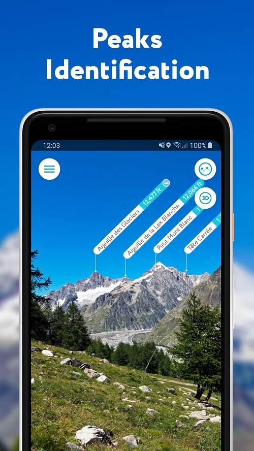
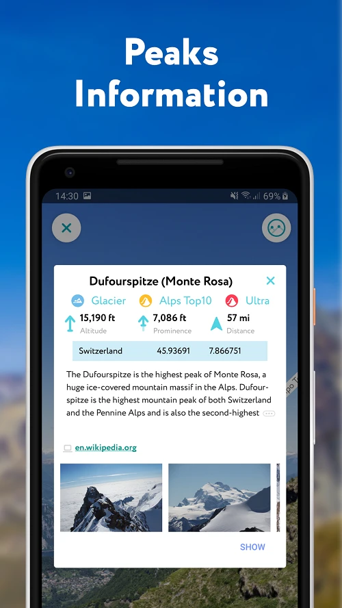
- Automatic Peak Identification: The app instantly recognizes over 150,000 named peaks globally using machine learning algorithms, providing detailed information including elevation, prominence, and historical significance with just a tap. This saves hours of manual research time when conducting geographical surveys or identifying landmarks during expeditions.
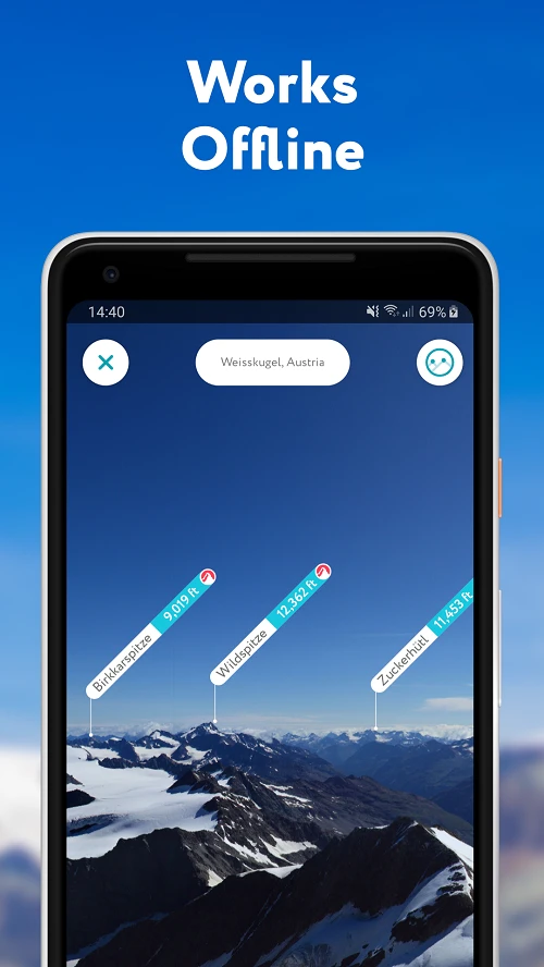
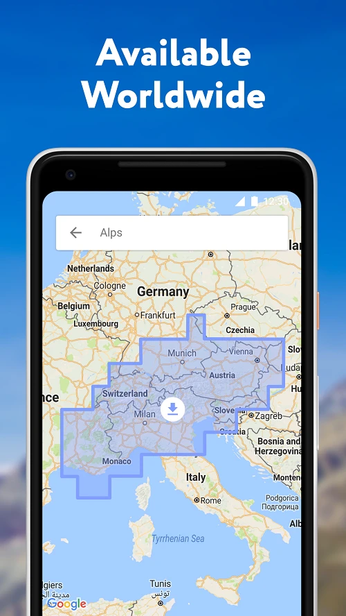
- Offline Mapping System: Download detailed map tiles for specific regions to use completely offline, with cached data persisting even when connectivity is lost. This is particularly valuable when exploring remote wilderness areas where cellular coverage is unreliable or unavailable.
- Elevation Profile Generator: Create detailed graphs showing elevation changes along any path segment, helping you visualize terrain undulations and anticipate physical exertion levels during hikes. This tool is especially useful for planning multi-day trekking routes that require careful altitude management.
- Multi-Layer GIS Integration: Access various data overlays including satellite imagery, contour lines, administrative boundaries, and point-of-interest markers, all synchronized in real-time. Environmental scientists find this feature invaluable for correlating landforms with ecological zones during field research.
- Data Export Functionality: Export route coordinates, elevation data, and peak information as GPX files or CSV spreadsheets for use in other geospatial applications. This interoperability makes the app compatible with professional surveying equipment and analysis software.
Pros & Cons
Pros:
- Highly detailed 3D terrain rendering
- Comprehensive peak identification database
- Intuitive user interface for outdoor use
- Excellent offline functionality
Cons:
- Higher data consumption when using cloud features
- Limited customization options for visualization
- Premium subscription required for advanced features
- Occasional GPS inaccuracies in dense forest canopies
Similar Apps
| App Name | Highlights |
|---|---|
| SummitSeeker Explorer |
Focuses on trail navigation with collaborative user routes. Includes caching system and community reviews. |
| Altitude Atlas |
Emphasizes elevation analysis with terrain prediction. Strong integration with weather forecasting services. |
| PeakPilot Mapping Suite |
Professional-grade GIS tool with advanced editing capabilities. Supports custom coordinate systems and land management. |
Frequently Asked Questions
Q: Does PeakVisor work without an internet connection?
A: Yes, once base maps are downloaded, the app works completely offline. For optimal performance, download region-specific tiles before venturing to remote locations. The 3D rendering quality remains excellent even with limited connectivity.
Q: Can I use this app for scientific geological research?
A: Absolutely! The app’s comprehensive database includes geological markers and allows field verification of identified features. Researchers find the peak identification and terrain analysis tools particularly valuable for preliminary geological surveys in remote areas.
Q: What devices support the app’s AR navigation feature?
A: Augmented Reality functionality is available on compatible smartphones with TrueDepth cameras (iPhone X and newer, or Android devices with similar sensors from 2020). The system requires at least 2GB RAM for smooth operation in mixed lighting conditions.
Q: How often is the peak database updated?
A: We update our database monthly with new survey data from sources like USGS and national mapping agencies. The automatic update system runs when connected to Wi-Fi to conserve mobile data, though manual updates are also available in Settings → Data Management.
Q: Are there any limitations on map download sizes?
A: Free users can download up to 1,000MB of map data. Premium subscribers receive unlimited downloads plus priority cloud storage, background downloads, and automatic map updates without storage optimization prompts.
Screenshots
 |
 |
 |
 |
PeakVisor – 3D Maps & Peaks ID App Download |
|
|---|---|
 |
 |