
 |
|
| Rating: 4.8 | Downloads: 1,000,000+ |
| Category: Maps & Navigation | Offer by: Iternio Planning AB |
A Better Routeplanner (ABRP) is an advanced route planning application specifically designed for electric vehicles (EVs), plug-in hybrids, and motorcyclists. It calculates optimal routes considering factors like battery range, charging station availability, speed limits, and elevation gain or loss, offering detailed insights and suggestions to maximize range and minimize journey risks. Primarily targeted at EV drivers, cyclists, and motorcyclists seeking efficient and reliable long-distance travel options.
The key appeal of ABRP lies in its detailed, data-driven route recommendations which help users avoid range anxiety, find compatible charging or refueling options along the way, and potentially save time and energy by factoring in real-world conditions like traffic or weather (if enabled). It provides a comprehensive overview of a trip’s feasibility, making long-distance travel significantly more stress-free and predictable for users of these vehicle types.
App Features
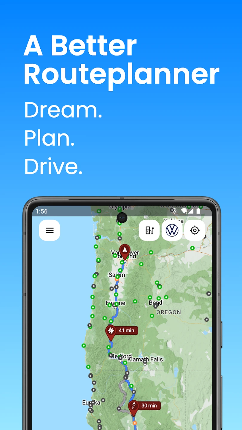
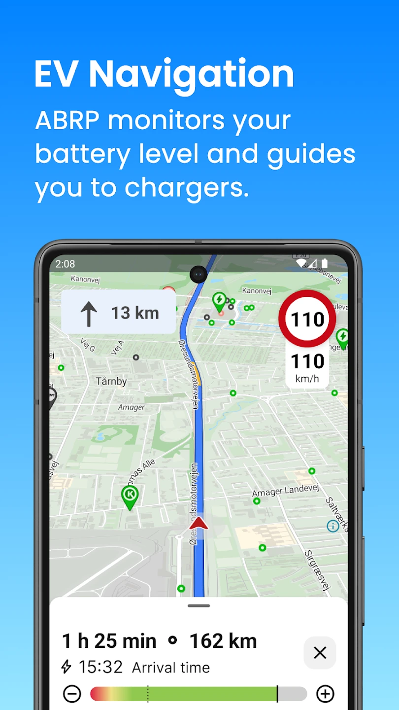
- Advanced EV Route Calculation: This core feature calculates routes specifically tailored for electric vehicles, analyzing battery capacity, energy consumption, and the nearest compatible charging stations to ensure the trip is viable and optimizes range usage, preventing unexpected battery depletion during travel. It considers elevation changes and local traffic data to provide realistic estimates of battery drain.
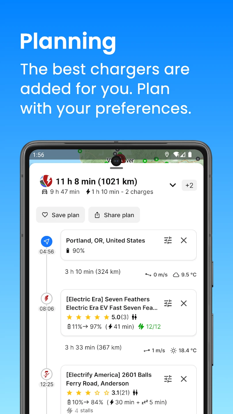
- Detailed Battery Management & Consumption Tracking: Users can input precise vehicle data, including battery size, energy consumption rates (Wh/km), and payload weight. The system then simulates the trip, showing projected battery level at key points, estimated time to charge, and detailed breakdown of energy consumption, allowing for informed decisions about range versus route flexibility.
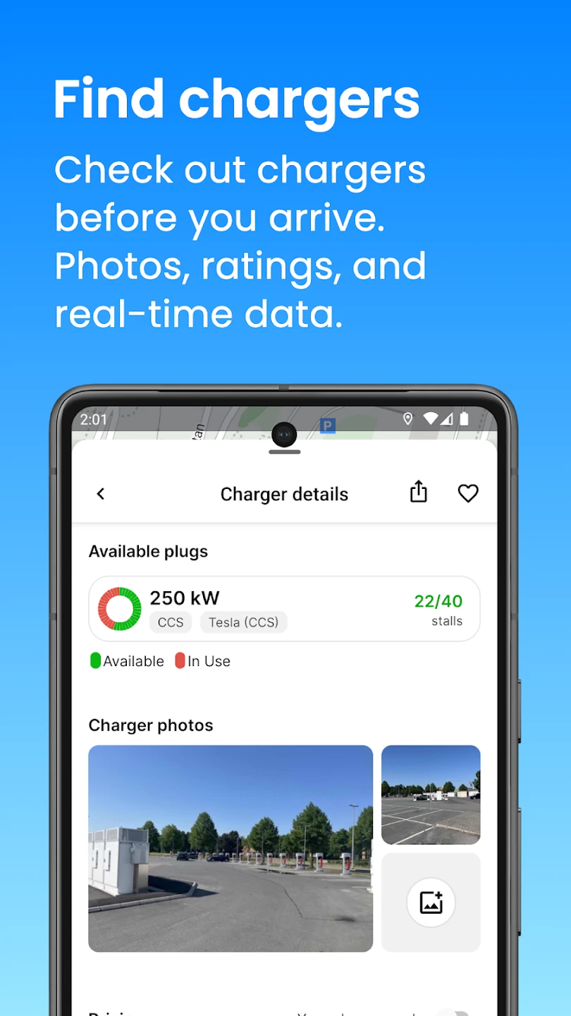
- Comprehensive Charging Infrastructure Integration: ABRP pulls data on a vast network of charging stations globally, displaying locations, connector types (AC/DC, CHAdeMO, CCS, etc.), charging power availability, and user reviews. This helps users identify and navigate towards suitable charging points based on time constraints or preferred amenities, minimizing search time during long journeys.
- Multi-Modal Routing (EV, Motorcycle, Pedestrian): Beyond EVs, the app can plan efficient routes for motorcyclists, cyclists, or even pedestrians. For motorcycles, it factors in lower speeds on certain roads, potential for overtaking, and road width. Cyclists benefit from suggestions prioritizing bike lanes and less congested paths, while pedestrian routes avoid busy streets and prioritize safety.
- Compatibility & Integration Across Platforms: Available on various platforms including web, iOS, and Android, the app syncs user profiles, vehicle details, and saved routes seamlessly between devices. Its open-source nature allows for extensive customization and plugin development by the community, adding functionalities like route cost calculators or integration with other tools. This offers significant flexibility, catering well to both casual users and those with complex routing needs, including specific fleet management requirements.
- Offline Map Usage & Route Synchronization: Users can pre-download map data for offline use, crucial for travel in areas with spotty connectivity or during long trips. Route details and navigation information can be automatically sent to navigation apps like Navionics or TwoNav, ensuring seamless transition from planning to real-world execution without constantly switching applications. This is highly valuable for users prioritizing reliability in remote areas.
Pros & Cons
Pros:
- Highly Accurate and Detailed Route Planning
- Extensive Charging/Refueling Station Database
- Advanced Battery Range Simulation
- Multi-Modal Routing Flexibility
Cons:
- Complex Interface for Beginners
- Requires Detailed Vehicle Information
- Occasional Data Synchronization Delays
- Free Tier Limitations on Advanced Features
Similar Apps
| App Name | Highlights |
|---|---|
| RouteMaster Pro |
Focuses on simplicity and mobile-first usability, with streamlined controls and guided setup processes. Ideal for users prioritizing ease-of-use over complex battery simulations. |
| EV Planner AI |
Offers AI-powered automation features for suggesting routes based on user history, traffic predictions, and even personal driving styles. Includes advanced export options and collaborative tools for shared trips. |
| ChargeMapper |
Designed primarily for charging station discovery and navigation, often integrating social feeds and user ratings for stations. Good if station details are the main focus, but less comprehensive for full route planning. |
Frequently Asked Questions
Q: How does ABRP account for my specific EV’s range and consumption?
A: ABRP requires you to input your vehicle’s make, model, battery capacity, and energy consumption figures (like kWh per 100 km). Using this data, combined with real-time traffic and elevation profiles, ABRP accurately calculates the estimated range remaining at any point on your trip.
Q: Is ABRP free to use, and are there premium features?
A: Yes, the core route planning functionality is free. However, A Better Routeplanner (ABRP) Community edition offers access to all features. ABRP Pro is a premium tier that removes certain data limitations (like the number of charging points considered) and adds advanced features for power users, available for a subscription fee.
Q: Can I plan routes specifically for my motorcycle on ABRP?
A: Yes, definitely. ABRP includes a dedicated mode for motorcycle routing (and also for cyclists). This mode adjusts calculations based on factors relevant to motorcycles, such as lower speed limits, road width, overtaking opportunities, and often avoids certain types of roads like tunnels or bridges where parking might be restricted.
Q: How up-to-date is the charging station information in ABRP?
A: ABRP continuously tries to keep its extensive database updated using multiple sources. While efforts are made to ensure accuracy, users are encouraged to report any outdated or incorrect station information directly within the app. The frequency of updates varies for different station types and regions.
Q: Does ABRP work offline once a route is planned?
A: Yes, ABRP allows users to download map data for specific areas or the entire route beforehand. Once this offline map (containing roads, towns, and POI data) is downloaded and the route planned using it, the navigation and route display functions will work even without an internet connection, ensuring reliable planning and execution in remote areas.
Screenshots
 |
 |
 |
 |
A Better Routeplanner (ABRP) App Download |
|
|---|---|
 |
 |