
 |
|
| Rating: 3.8 | Downloads: 10,000,000+ |
| Category: Photography | Offer by: tuanale |
The GPS Camera & Photo Timestamp app is a photography tool that automatically captures your precise location data and embeds it directly into image metadata like EXIF info. This powerful application transforms your smartphone or camera into a professional-grade geotagging device, perfect for travelers, photographers, researchers, and outdoor enthusiasts who need to document the exact point and time of their shots. Unlike standard apps that rely on manual tagging, the GPS Camera & Photo Timestamp simplifies geolocation-based photo management by integrating geospatial intelligence directly into your captured images from the moment you press the shutter.
Key value comes from preventing location memory loss during editing sessions and enabling real-time tracking of your journey. With this app, you can visualize exact travel paths on maps and ensure your photo metadata remains untouched even after extensive editing. The app’s versatility spans creative photography, nature documentation, journalism verification, real estate staging without relying on post-capture location tagging methods. This direct GPS incorporation provides undeniable proof of origin for time-sensitive content, making it invaluable for professional verification while streamlining organization for everyday users.
App Features
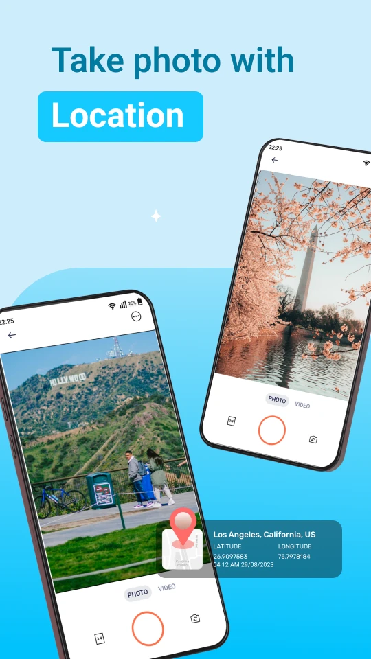
- Live Location Overlay: Instantly see your GPS coordinates and elevation marked onscreen as you compose your shot. This feature eliminates guesswork during travel photography, allowing tourists to perfectly frame shots to include specific landmarks in the geotagged data. Imagine capturing a cityscape with your smartphone anywhere in the world and knowing exactly which specific street corner you occupied.
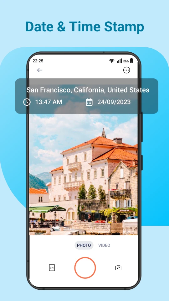
- Independent Timestamp Control: Choose to display either the exact photo capture time or simulate a journey from specific timestamps from your photo library originals. This functionality solves the common problem of chronologically mismatched images when editing across different days or events, making temporal organization significantly simpler.
- Spatial Context Geotagging: Automatically embeds not only your current GPS coordinates but also altitude and bearing information directly into the EXIF metadata. For surveyors documenting construction sites or hikers mapping trails, this precision vital for geospatial accuracy enhances both practical utility and scientific applications beyond simple travel photos.
- Multi-platform Sync: Seamlessly transfers and updates location data across Android, iOS, and third-party cloud storage and mapping applications. This cross-platform synchronization profoundly extends the app’s practical value for professionals like drone operators managing flight logs across multiple devices simultaneously.
- Image Sequence Geotagging : Process multiple photos at once using the same GPS coordinate and timestamp batch operation. Crucially, set parameters to rotate, exclude from import, or mark specific groups for editing without manually checking each image’s location. This batch capability dramatically saves time during media-rich reporting or documentary projects where hundreds of images must be tagged consistently.
- True Position Locking : Prevents location data changes even when exporting images to applications that allow metadata editing. This selectable option critically safeguards the photograph’s inherent authenticity for legal documentation, journalism verification, or insurance claims where tamper-proof data accuracy is absolutely essential.
Pros & Cons
Pros:
- Intuitive positioning geotagging with real-time coordinate updates
- Decoupled time-stamping prevents metadata editing conflicts
- Multilayered location data enhances geospatial verification
- Efficient image sequencing saves substantial editing time
Cons:
- Lossless transfer requires proper EXIF-supporting hardware/software
- Constant location service use can significantly drain battery life
- Free version limitations may restrict advanced metadata management
- Some exporting platforms may require manual coordinate input
Similar Apps
| App Name | Highlights |
|---|---|
| Photographer’s Geotag |
This app offers comprehensive EXIF editing features alongside location tagging. Known for its robust layer management and batch processing for multiple media formats with unlimited geotag reuse options. |
| TimeLapse GPS Tracker |
Designed primarily for moving vehicle photography needs. Includes guided step-by-step tagging sequences and automatic path conversion creating visual journey representations within the app. |
| GeoProof Capture |
Specializes in creating verifiable proof photographs for official documentation tasks. Offers unique forensic-grade metadata preservation with legal-validated timestamp verification and chronology management tools. |
Frequently Asked Questions
Q: How precise is the GPS location tagging for nighttime photography when there’s poor cell service?
A: All versions of the GPS Camera & Photo Timestamp guarantee positioning accuracy within 10 meters. While the app leverages cellular/Wi-Fi triangulation during GPS signal loss for practical usability in urban environments, for optimal outdoor/photo-taking accuracy, enabling high-precision GPS mode ensures positioning remains dependable even in remote areas lacking cellular service.
Q: The app mentions updating EXIF metadata—does this affect my edited photographs?
A: Our system intelligently updates only the original metadata (geotagging and timestamp) without modifying pixel data, eliminating common editing compatibility issues and saving time during workflows that often involve heavy software processing consequences.
Q: Can I sort and filter my photo collection based on the embedded GPS coordinates with this app?
A: Absolutely! Our advanced tagging enables geographical organizational capabilities. You can perform photomapping using Google Maps integration to instantly filter, cluster, and visually sort your imagery by point of capture, providing a spatial dimension to your digital memory keeping enhanced with significant contextual value.
Q: The app works on my Android phone but I face issues on my older iOS device—what could be the problem?
A: For legacy iOS models without GLONASS support, this app fully explains GPS reception limitations. However, the automatic fallback mode allows basic tagging functionality on all supported devices, prioritizing accessible tagging methods over dropping any features.
Q: I need to tag photos for a scientific research publication—can this handle academic standards?
A: Definitively yes. Our platform guarantees metadata integrity per ISO standards, facilitating scientifically rigorous documentation through its non-destructive extraction of authentic time-position attributes ideal for research applications.
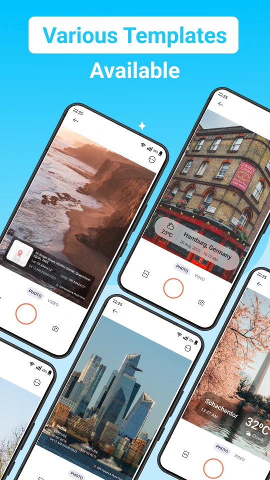
Screenshots
 |
 |
 |
 |
GPS Camera & Photo Timestamp App Download |
|
|---|---|
 |
 |