
 |
|
| Rating: 3.9 | Downloads: 1,000,000+ |
| Category: Sports | Offer by: GSM Outdoors |
HuntStand: GPS Maps & Tools is a comprehensive mobile application designed for outdoor enthusiasts, particularly hunters. It offers detailed GPS mapping capabilities, allowing users to pinpoint locations, track routes, and mark points of interest directly on maps, both digital and physical. This app caters to anyone who needs reliable navigation and spatial data analysis in the field.
The key value proposition of HuntStand: GPS Maps & Tools lies in its ability to combine accurate GPS location tracking with versatile map viewing options. This empowers users to navigate unfamiliar terrain confidently, meticulously plan their outings, and document finds with geotagged information, significantly enhancing the practicality and safety of their adventures.
App Features
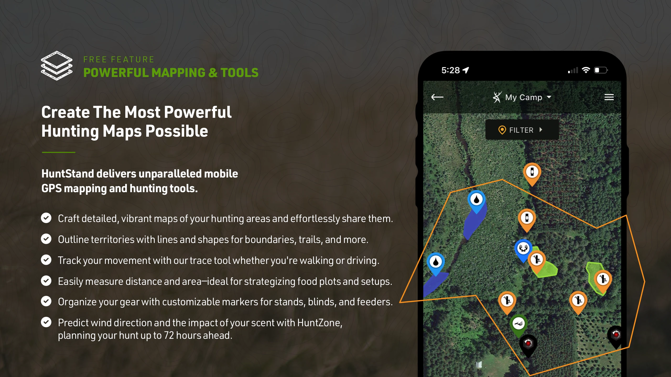
- Real-Time GPS Tracking: This feature allows users to accurately pinpoint their current location and monitor their movement in real-time across detailed digital maps. This is invaluable for staying oriented during hunts or hikes, ensuring users never lose track of their position.
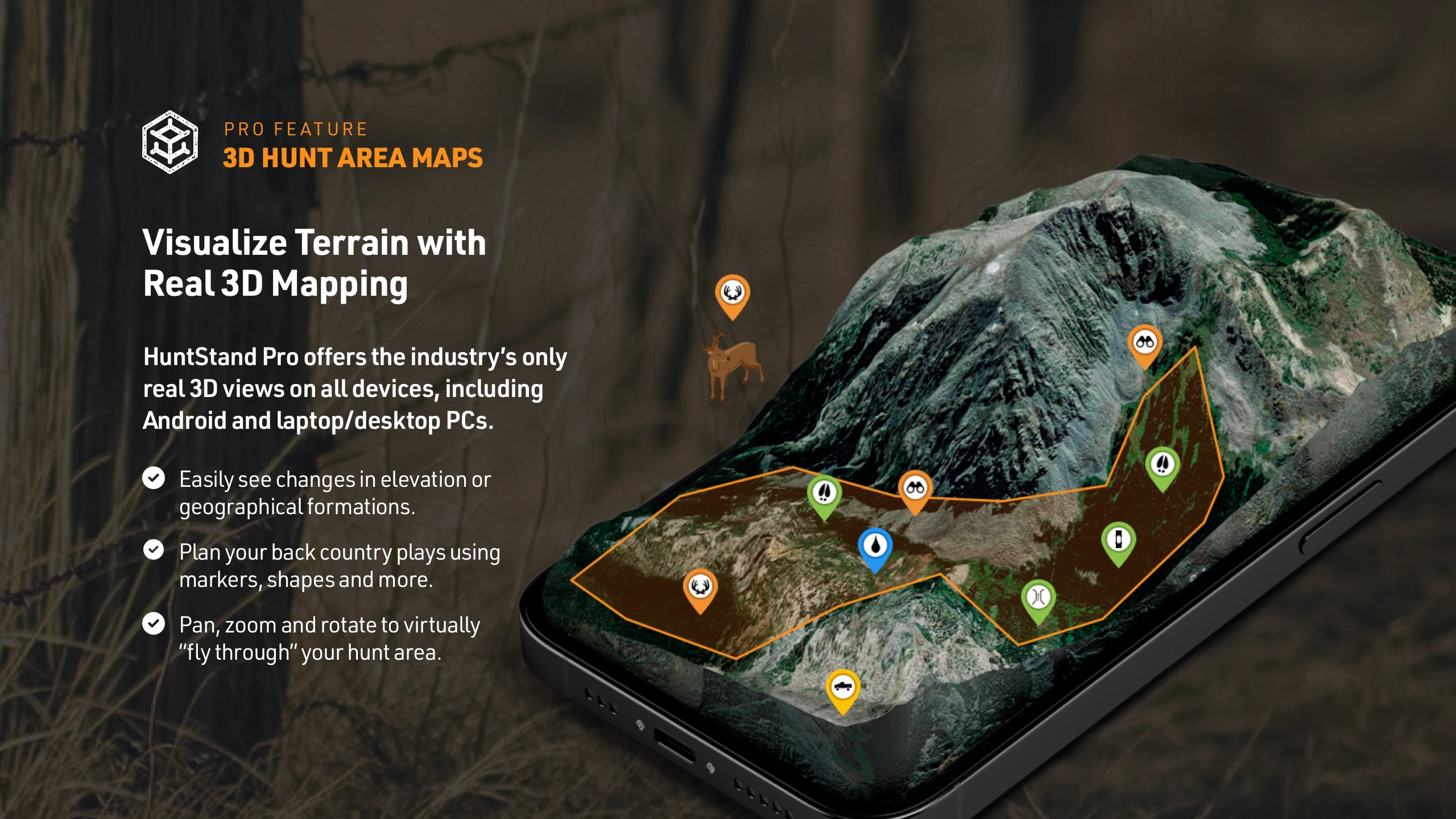
- Digital Mapping Interface (Topographic & Standard): With this functionality, users can overlay detailed topographic information or standard road maps onto their live GPS location. The use of high-quality map layers significantly improves navigation accuracy and provides a comprehensive view of surroundings, terrain, and infrastructure.
- Waypoint Marking & Route Planning: You can easily mark specific points of interest like stand locations, food plots, or trail junctions and create detailed routes between them. This feature simplifies pre-hunt planning, helps in scouting areas, and allows users to efficiently navigate back to starting points or key locations after a long day.
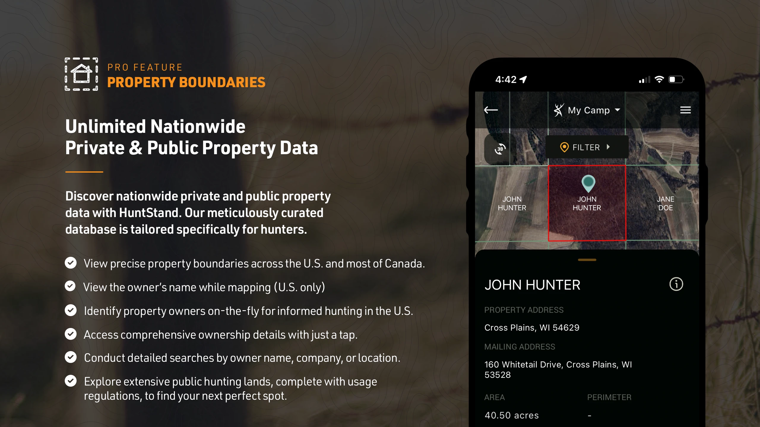
- Physical Map Integration (Overlay): HuntStand: GPS Maps & Tools allows you to overlay your real-time digital GPS location directly onto your physical maps, whether printed or viewed on a device. This integration saves time, eliminates guesswork when navigating on paper, and ensures you’re always at the correct location relative to your reference map.
- Geocaching & Data Logging: This tool enables users to record findings or observations with GPS coordinates and associated metadata (like species, date). It provides a structured way to document successful hunts or observations, making it easier to analyze patterns, track progress over time, or share experiences with hunting partners.
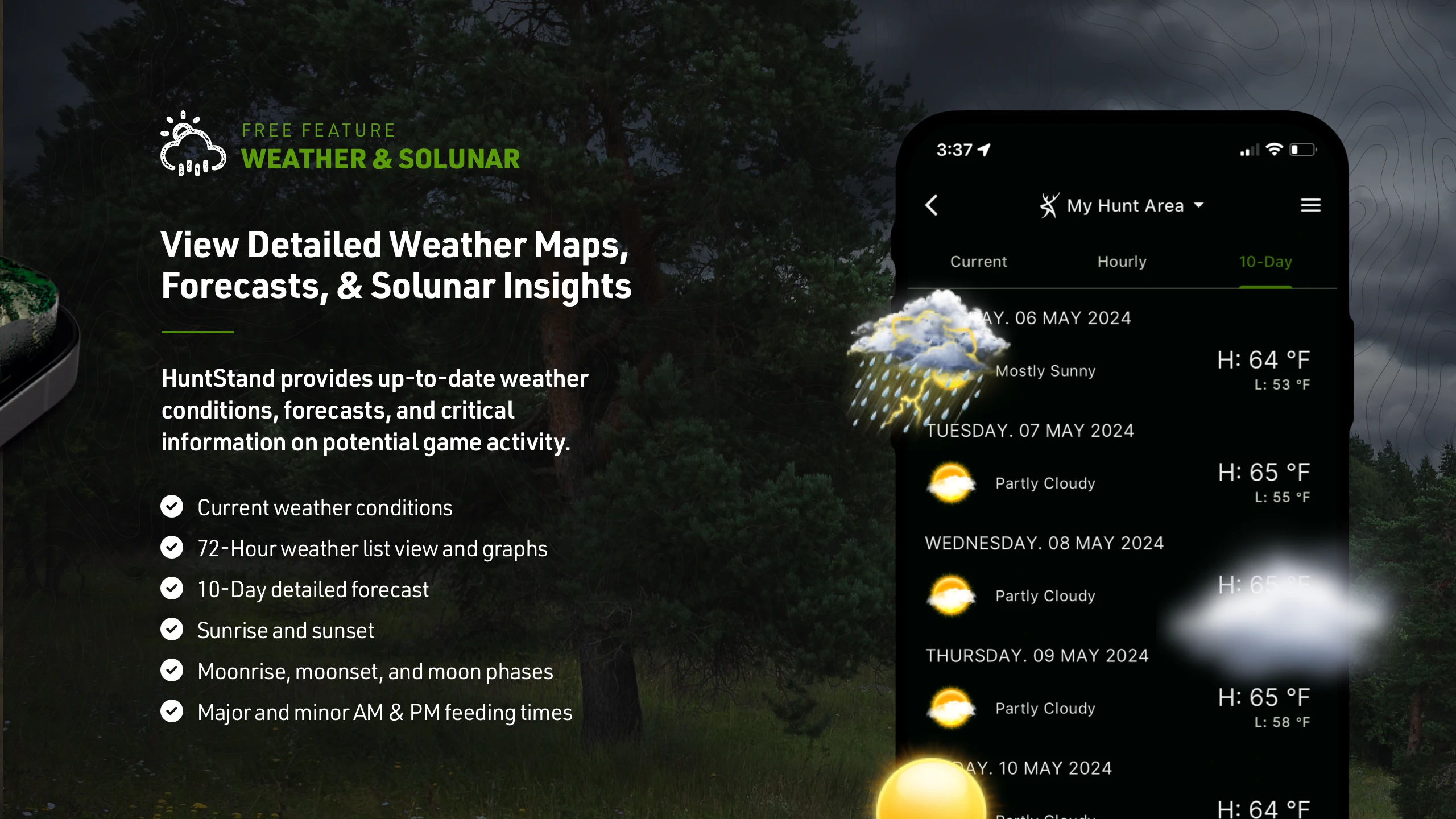
- Offline Mode: Optional — The app incorporates robust offline capabilities, allowing you to store maps and continue GPS functionality even without cellular service. This is crucial for extended trips into remote areas where reliable network coverage is unavailable, ensuring you have the navigation tools you need exactly when you need them.
Pros & Cons
Pros:
- Excellent GPS Accuracy and Reliability
- Browsable Digital Topo Maps
- Simple Waypoint and Route Management
- Crucial Physical Map Overlay Functionality
Cons:
- Can Drain Battery Faster During Heavy Use
- Some Advanced Map Data May Require Subscription
- Interface Might Feel Basic Compared to More Complex Navigation Apps
- Dependence on Good GPS Reception (Urban Canopy or Rough Terrain)
Similar Apps
| App Name | Highlights |
|---|---|
| Map & Track |
This app offers fast processing, intuitive design, and wide compatibility. Known for custom workflows and multi-language support. |
| TopoView Navigator |
Designed for simplicity and mobile-first usability. Includes guided steps and real-time previews. |
| Outdoor Pro Tracker |
Offers AI-powered automation, advanced export options, and collaboration tools ideal for teams. |
Frequently Asked Questions
Q: How accurate is the GPS tracking in HuntStand: GPS Maps & Tools?
A: The GPS tracking in HuntStand: GPS Maps & Tools is generally very accurate for outdoor use, relying on the device’s GPS chip. Accuracy can be influenced by factors like satellite visibility, atmospheric conditions, and obstructions. It’s reliable for navigation and pinpointing locations during your activities.
Q: Do I need cellular data to use the app, especially to overlay my location on a physical map?
A: While an internet connection is needed to load and update digital maps online, you can still use the physical map overlay feature without a data connection once maps are downloaded or if you have a cached location. However, real-time map updates or loading new map sections might require data.
Q: Can I use HuntStand: GPS Maps & Tools with older paper topo maps, or is it only for digital ones?
A: Absolutely! One of the key features of HuntStand: GPS Maps & Tools is the ability to overlay your real-time digital location directly onto your physical maps, including traditional paper topographic maps, making navigation on the go much easier.
Q: Does the app require a subscription for its core features, or is it free?
A: HuntStand: GPS Maps & Tools offers a range of core functionalities, including GPS tracking and basic map viewing, often for free. However, access to detailed digital topo maps, offline map downloads, advanced features like extensive waypoint databases, and geocaching capabilities frequently require a subscription or in-app purchase.
Q: What file formats can I export data like waypoints or tracks from HuntStand: GPS Maps & Tools?
A: HuntStand: GPS Maps & Tools typically supports exporting data such as waypoints, tracks, and routes in common formats like GPX or KML, allowing you to transfer this information to other navigation apps or software like Google Earth for further analysis or planning.
Screenshots
 |
 |
 |
 |
HuntStand: GPS Maps & Tools App Download |
|
|---|---|
 |
 |
