
 |
|
| Rating: 3.9 | Downloads: 50,000+ |
| Category: Photography | Offer by: Civi Corp |
Solocator – GPS Field Camera is a dedicated mobile application designed for capturing high-quality photographs and videos while simultaneously recording precise GPS coordinates. It integrates GPS technology directly with your smartphone’s camera, ensuring every picture and clip is automatically tagged with its exact location, date, and time. Ideal for professionals such as surveyors, environmental researchers, real estate agents, hikers, and construction workers who need accurate geographical context for their media.
The key value of Solocator lies in its simplicity and reliability for field documentation. Instead of relying on complex external devices or manually noting down locations, users can effortlessly capture geotagged media directly from their phone, significantly streamlining workflows and ensuring data accuracy in the field. Its appeal stems from providing essential location intelligence directly attached to visual evidence, making it invaluable for mapping, asset tracking, scientific logging, and sharing location-specific information.
App Features
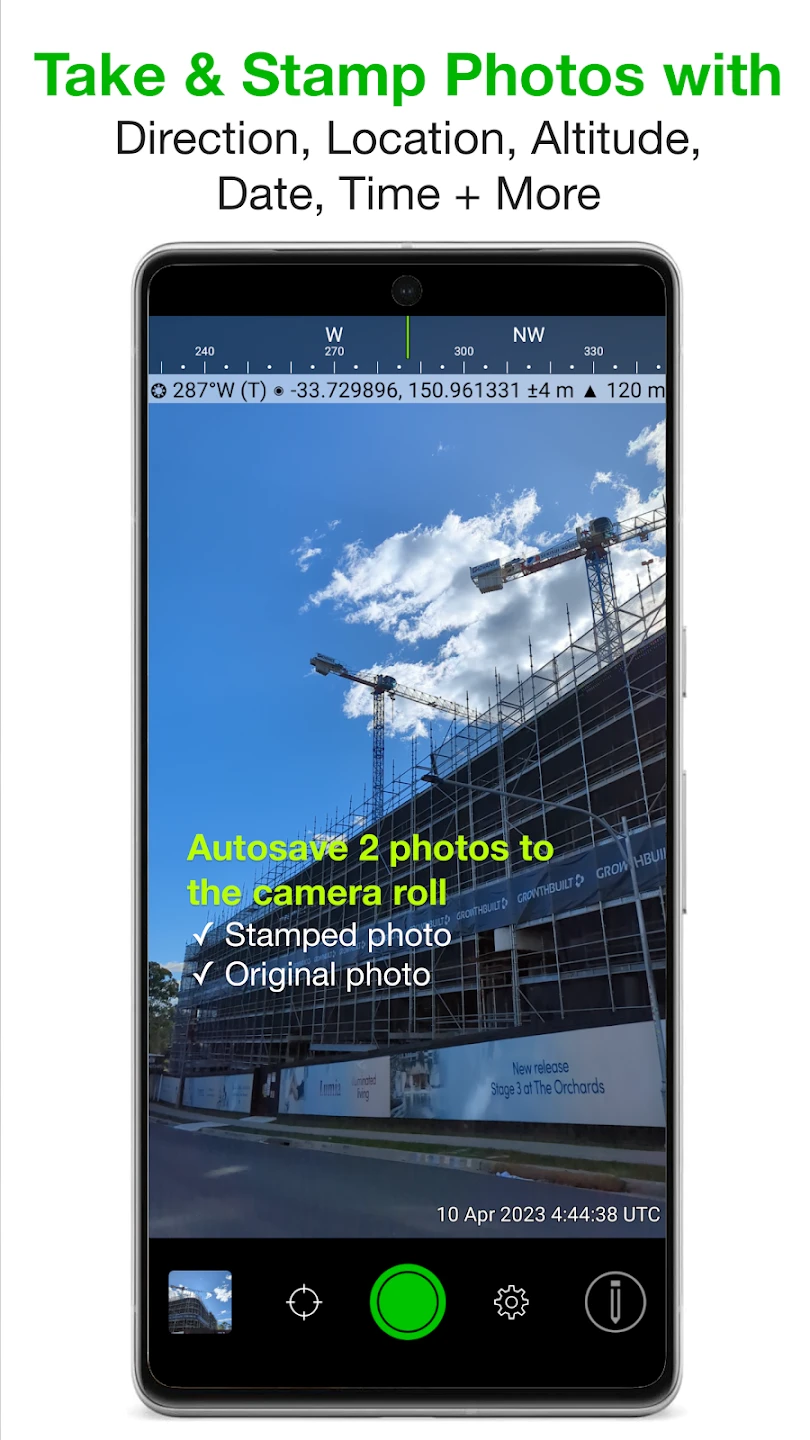
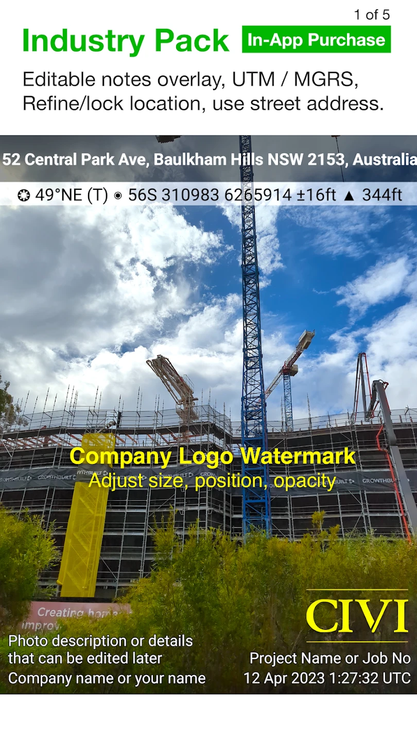
- Automatic Geotagging: Every photo and video taken using Solocator is instantly stamped with its exact GPS location, date, and time, eliminating the need for post-capture editing. This saves significant time, especially in large survey or research projects where hundreds or thousands of images require location data, and ensures the metadata is accurate and consistent from the moment the media is recorded.
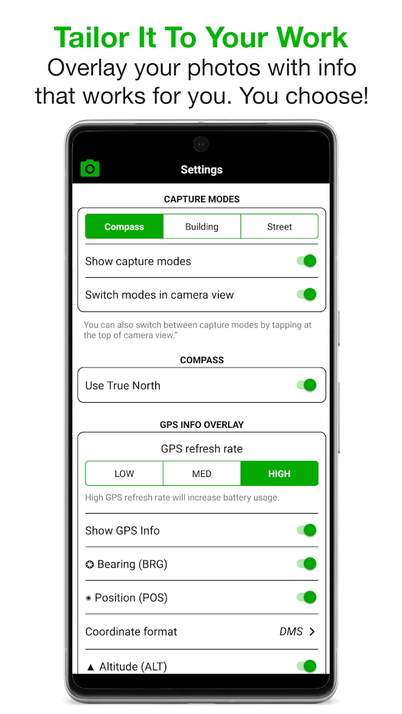
- Camera Integration & Settings: Solocator leverages the native camera hardware on your smartphone, offering options to adjust quality settings like resolution (e.g., Full HD, HD), photo/video mode, and flash control. This ensures high-fidelity capture tailored to specific needs while benefiting from the latest smartphone camera advancements. The integration guarantees maximum photo and video quality directly from your device, without relying on external hardware compromises.
- Built-in Compass Display (Beta): An integrated compass overlay provides a visual representation of north and bearing relative to the captured media, displayed directly in the viewfinder and within the media details. This allows for immediate orientation checks during capture and helps in verifying alignment or directionality, proving particularly useful for mapping tasks, archaeological surveys, or any application requiring precise directional context alongside geographical coordinates. The beta status indicates ongoing refinement for accuracy and usability.
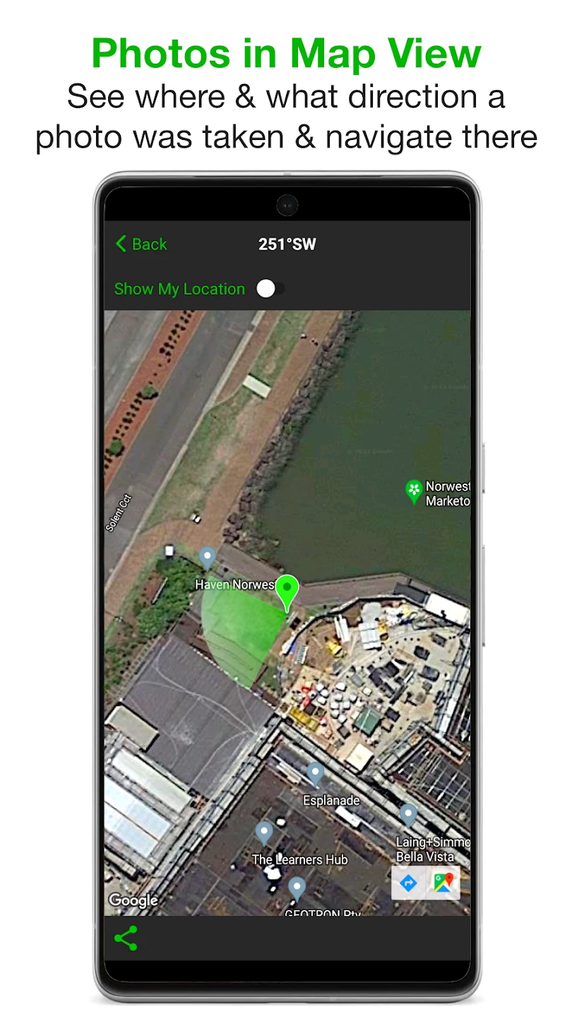
- GPS Point Tracking & Logging: Users can manually place GPS points on the map or while moving. These waypoints are linked to the most recent media capture, allowing easy logging of multiple entries at different locations. This feature is invaluable for documenting inspection routes, tracking specimen locations during field research, or mapping multiple assets. It simplifies the process of creating a chronological and spatially-aware log of field activities, directly associating each observation with its exact coordinates.
- User Notes & Exif Data: Beyond basic location tagging, Solocator allows users to add descriptive notes directly to captured photos and videos. The application also preserves standard EXIF metadata, including device model, focal length, and aperture information (if applicable), alongside the automatically added GPS data. This comprehensive metadata ensures full context for the media, crucial for professional documentation, compliance, and detailed record-keeping across various industries.
- Offline Mapping & Data Storage: Solocator functions reliably even without an active internet connection, allowing GPS tracking and media capture in remote areas or underground. The app stores all captured data locally on the device or cloud-synced storage. This offline capability is critical for fieldwork in areas with poor or no cellular service, ensuring users can still perform their tasks and have their data accessible when connectivity is restored or for immediate post-field processing.
Pros & Cons
Pros:
- Simple and Direct Geotagging
- Leverages High-Quality Smartphone Cameras
- Portable and Hands-Free Solution
- Reliable Offline Functionality for Fieldwork
Cons:
- Potential GPS Lag or Accuracy Issues in Dense Areas
- Dependence on Smartphone Battery Life
- Interface Might Have a Moderate Learning Curve
- Storage Limits Depending on Device
Similar Apps
| App Name | Highlights |
|---|---|
| FieldLens GPS |
Focuses on field data logging alongside geotagging. Offers robust point creation tools and integration with external GPS modules for potentially higher accuracy. Great for surveyors and land managers. |
| SurveyPro Mobile |
Designed specifically for construction site and infrastructure surveying. Includes advanced measurement tools (like tape measure), drawing capabilities, and detailed reporting alongside media capture and GPS tagging. |
| EcoTrack Field |
Tailored for environmental scientists and researchers. Provides specialized data entry forms for species sightings or ecological observations, combined with high-resolution geotagging capabilities and detailed map overlays (like habitat layers). |
Frequently Asked Questions
Q: Does Solocator work without an internet connection?
A: Yes! Solocator excels in offline environments. You can record GPS tracks, take photos, videos, and add notes entirely without cell service or Wi-Fi access, perfect for remote fieldwork.
Q: How accurate is the GPS tagging in Solocator?
A: Solocator relies on your device’s built-in GPS receiver for accuracy. Modern smartphones typically offer GPS precision within a few meters in open skies, though signal quality may vary indoors or in dense forests, affecting accuracy.
Q: Can I use Solocator for professional photography projects?
A: Absolutely. Solocator adds crucial geospatial context to your photos, making it ideal for location-based journalism, real estate photography (proving property boundaries), event documentation, and scientific research. The quality is smartphone-based, which is often sufficient for many professional needs.
Q: What happens to my GPS points and media if I stop using the app?
A: Your data is stored locally on your phone. You can view it within Solocator, export it via files, or use cloud sync features (if enabled). Stopping the app only pauses it until you return; your data remains safely on your device unless manually exported or deleted.
Q: Can other people see the location information in my photos/videos?
A: By default, GPS data is embedded in the EXIF metadata of your media files. Anyone viewing these files (if the software allows) can potentially see the location information. For privacy, you may need to use separate tools to edit or remove this metadata if sharing photos outside of your intended audience.
Screenshots
 |
 |
 |
 |
Solocator – GPS Field Camera App Download |
|
|---|---|
 |
 |