
 |
|
| Rating: 4.1 | Downloads: 100,000+ |
| Category: Weather | Offer by: DTN LLC |
RadarScope is a specialized application designed to visualize and analyze weather radar data. It provides users with detailed access to Doppler radar imagery from various sources, enabling them to track storms, monitor precipitation intensity, and understand atmospheric movement patterns for improved forecasting and awareness. This tool is essential for weather enthusiasts, professional meteorologists, aviation personnel, event planners, and anyone needing reliable and detailed current weather insights readily available on their mobile device.
Its key value lies in transforming complex, often computer-based radar data into a user-friendly mobile experience. RadarScope allows for easy panning, zooming, and layer switching (like reflectivity and velocity scans) directly on your phone or tablet, making interpreting weather data significantly quicker and more accessible for immediate planning and safety decisions.
App Features
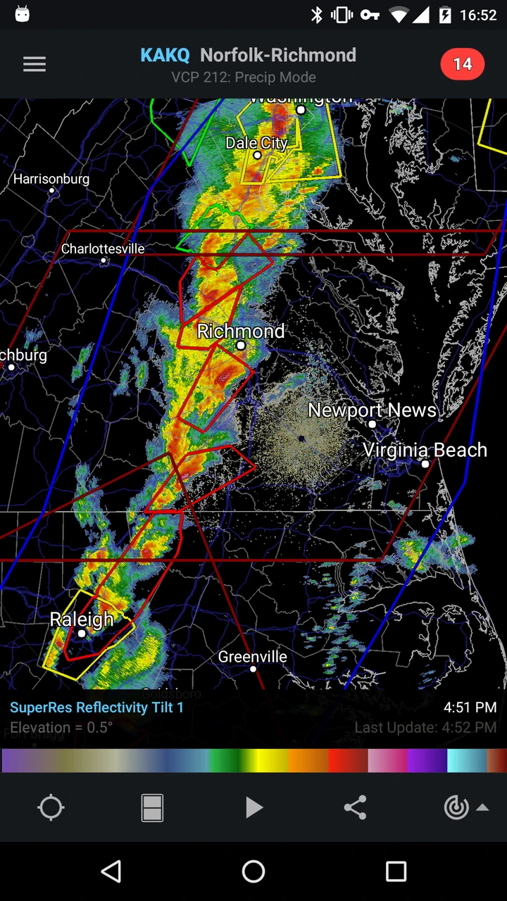
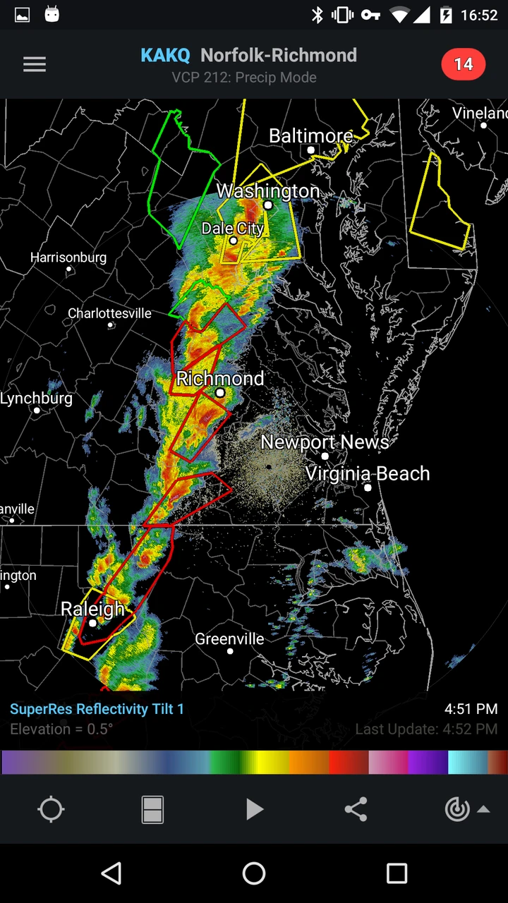
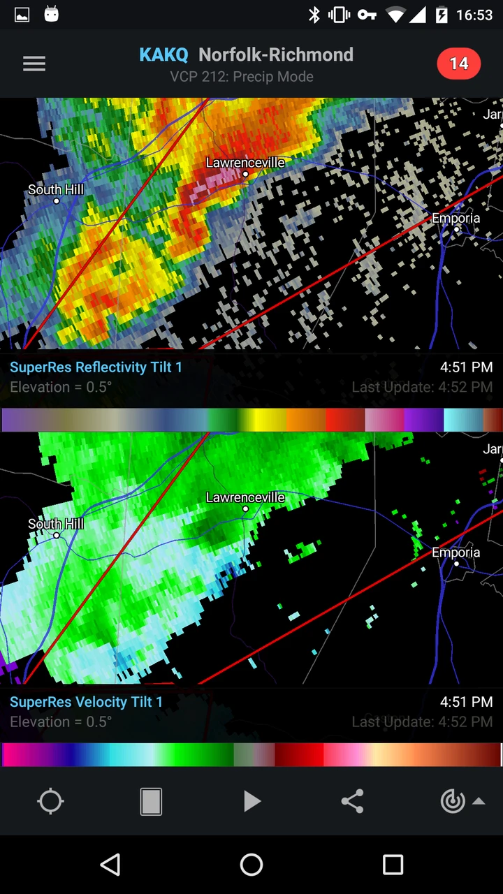
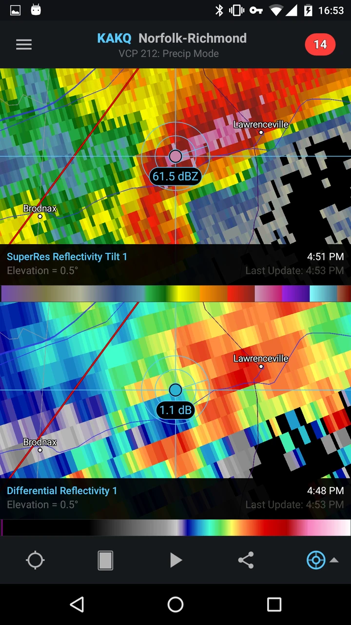
- Data Import & Visualization: RadarScope allows users to select and view radar data from multiple sources (NWS, Environment Canada, international partners) directly on the map interface. This real-time access enables quick assessment of developing weather patterns and helps users understand current conditions without needing desktop software.
- Map Tools & Controls: The app includes intuitive map navigation tools, featuring panning, pinch-to-zoom, and the ability to toggle different radar layers (reflectivity, velocity base, storm relative velocity) or overlay overlays like county boundaries and significant weather warnings. These controls simplify complex data interpretation, making it easier for users to focus on specific areas or weather phenomena relevant to their needs.
- Data Export & Sharing: Users can capture radar images directly from the application, saving them as high-resolution PNG files. This feature is ideal for including visual weather information in reports, presentations, social media updates, or personal cloud archives for reference. Having the ability to easily share or store specific radar observations enhances the app’s utility beyond simple viewing.
- Radar Loop Animation: RadarScope generates time-lapse animations (loops) of radar data, allowing users to observe the development, movement, and dissipation of weather systems over a specified period. This function is particularly valuable for quickly understanding storm evolution, track prediction accuracy, and the broader atmospheric context surrounding a specific weather event. Animation saves time compared to reviewing static images sequentially and provides a clearer picture of dynamic changes.
- Customization & Settings: Users can configure the app to automatically refresh radar data at desired intervals (e.g., every 10 minutes), choose preferred radar basemap styles, adjust image quality settings based on device storage, and select specific radar sites or network layers. This flexibility allows RadarScope to adapt to varying user needs, from quick glance checking to detailed, long-duration monitoring tasks.
- Alert Integration (Optional): While not always bundled, some versions or companion features might include alerts based on detected severe weather indicators visible in the radar data (like hook echoes, bounded weak echo regions), providing timely notifications for users in potentially hazardous situations. This advanced capability significantly boosts user safety by integrating automated warnings directly with radar observation tools.
Pros & Cons
Pros:
- Excellent Radar Data Quality & Variety
- User-Friendly Interface & Smooth Controls
- Highly Customizable Display Options
- Convenient Data Export & Image Capture
Cons:
- Occasionally Laggy Data Refresh or Glitches
- Dependent on External Radar Feed Reliability
- Potentially High Storage Usage for Raw Images
- Subscription or Premium Tier May Be Required (Depending on Version)
Similar Apps
| App Name | Highlights |
|---|---|
| SkyView |
Offers high-resolution radar data and satellite imagery. Known for robust customization features and seamless integration with local weather alerts via direct feeds from official sources. |
| WeatherTrack |
Focuses on tracking severe weather and forecasts with a simple, touch-centric design. Includes guided steps for understanding radar terms and real-time storm tracking capabilities overlaying radar and road maps. |
| RainViewer |
Designed for simplicity and mobile-first usability. Includes guided steps and real-time previews. |
Frequently Asked Questions
Q: How do I use RadarScope to get the latest local weather radar?
A: Simply open the RadarScope app and tap the “Refresh Radar” button located in the map view or tap the refresh icon in the toolbar. The app automatically connects to the nearest available radar data source, typically fetching the most recent imagery. You can then pinch to zoom in on specific areas or pan around the map to view different parts of the coverage.
Q: What types of radar data does RadarScope typically show?
A: RadarScope usually accesses and displays data from sources like the National Weather Service (NWS) in the US, Environment Canada, or similar agencies internationally. Common data types include reflectivity (intensity of precipitation) and velocity (movement of particles) scans presented in both Plan Position Indicator (PPI) and Range-Height Indicator (RHI) views.
Q: Is RadarScope free to use, or are there costs involved?
A: RadarScope typically offers a core set of features for free, including basic radar viewing. However, access to premium features like advanced overlays, extended historical data playback, or certain high-resolution radar feeds (e.g., Level 3 NEXRAD) might require a subscription or in-app purchase for a Pro or Plus tier.
Q: Can I use RadarScope on both my phone and tablet?
A: Yes, RadarScope is primarily designed as a mobile app and is available for major smartphone and tablet platforms, such as iOS (iPhone/iPad) and Android (Google Play). The interface adjusts to different screen sizes, ensuring a good experience on both small phone screens and larger tablet displays.
Q: What should I do if the radar data seems outdated when I check RadarScope?
A: Radar data updates depend on the source feed and can have a lag (often a few minutes). Try tapping the refresh icon a few times; the app will attempt to pull the most recent data. If it still shows older data, wait a few additional minutes or check if there are any known outages or maintenance affecting the specific radar source you are viewing. Ensure your app is updated to its latest version.
Screenshots
 |
 |
 |
 |
RadarScope App Download |
|
|---|---|
 |
 |